
Severe storms have brought multiple tornado warnings as well as large hail and heavy rainfall to Oklahoma on Tuesday. >> Chief Meteorologist Damon Lane and the First Alert Weather Team are tracking tornado-warned storms in Oklahoma. Open the video player above for live team coverage. >> Go to the KOCO weather page | Get KOCO on the Go | Subscribe to KOCO 5’s YouTube channel 4:36 p.m. Tuesday Update: The tornado warning for Cleveland and Oklahoma County continues through 5 p.m. A severe thunderstorm warning also was issued for Cleveland, Grady, McClain and Oklahoma counties until 5:15 p.m. Damon says you should be prepared to see quick spin-ups with these storms. 4:33 p.m. Tuesday Update: Damon says there could be quick spin-ups with the severe storms moving through the Oklahoma City metro. Any spin-ups or rotation we’ve seen has not touched the ground. Storm Chaser Nick Smith spotted rotation that he called “really impressive visually” near Interstate 240 and Anderson Road. Open the video player below to watch.4:25 p.m. Tuesday Update: A tornado warning has been issued for southeastern Oklahoma County and northeastern Cleveland County until 5 p.m. Chief Meteorologist Damon Lane says we’re watching a tornado couplet near Lake Stanley Draper. Storm Chaser Nick Smith says he could hear the tornado sirens going off near Tinker Air Force Base. 4:15 p.m. Tuesday Update: The tornado warning that was issued for Noble County has been extended until 5 p.m.4:07 p.m. Tuesday Update: A new severe thunderstorm warning with ping pong ball-sized hail has been issued for Oklahoma County. A different severe thunderstorm warning was issued for Noble and Payne counties until 4:45 p.m.3:56 p.m. Tuesday Update: Chief Meteorologist Damon Lane says storms moving through Moore has been warned for golf ball-sized hail. 3:52 p.m. Tuesday Update: A tornado warning has been issued for Noble County until 4:15 p.m.3:48 p.m. Tuesday Update: A severe thunderstorm warning has been issued for Oklahoma County. Other severe thunderstorm warnings were issued for Jackson, Tillman, Garfield, Grant, Kay and Noble counties. 3:45 p.m. Tuesday Update: Chief Meteorologist Damon Lane says storms moving through Newcastle are warned for quarter-sized hail. 3:30 p.m. Tuesday Update: A tornado warning has been issued for far northern Oklahoma near Renfrow and Caldwell. The warning was issued for Grant and Kay counties until 4:15 p.m.3:20 p.m. Tuesday Update: Another severe thunderstorm warning has been issued for northern Oklahoma County near Edmond for a storm near Oak Tree National and Mitch Park. Chief Meteorologist Damon Lane says the storm is warned for quarter-sized hail. 3:17 p.m. Tuesday Update: A severe thunderstorm warning has been issued for Canadian, Cleveland, Grady, McClain and Oklahoma counties until 4 p.m. Chief Meteorologist Damon Lane says those storms are warned for 60 mph winds. 3:15 p.m. Tuesday Update: A severe thunderstorm warning has been issued for Jackson County until 3:45 p.m.2:58 p.m. Tuesday Update: Chief Meteorologist Damon Lane says storms that have produced 70 mph wind in western Oklahoma are moving through Dill City, Sentinel, Hobart, Altus and Weatherford. Those storms are tracking east and will eventually move into the OKC metro by the evening commute. 2:55 p.m. Tuesday Update: Non-severe storms are heading into the Oklahoma City metro, but they have the potential to produce strong winds. Chief Meteorologist Damon Lane and Field Meteorologist Michael Armstrong say the storms have had pockets of strong winds. Damon added that these storms could produce a heavy amount of rain, which pose a flooding threat. 2:27 p.m. Tuesday Update: The severe thunderstorm watch was expanded to include Craig, Creek, Mayes, Nowata, Okfuskee, Okmulgee, Osage, Ottawa, Pawnee, Rogers, Tulsa, Wagoner, and Washington counties.2:20 p.m. Tuesday Update: Severe thunderstorm warnings were issued for Greer and Kiowa counties as well as Washita County until 3 p.m. A severe thunderstorm watch also was issued for the following counties until 9 p.m.: Alfalfa, Beckham, Blaine, Caddo, Canadian, Carter, Cleveland, Comanche, Cotton, Custer, Dewey, Garfield, Garvin, Grady, Grant, Greer, Harmon, Hughes, Jackson, Jefferson, Kay, Kingfisher, Kiowa, Lincoln, Logan, McClain, Major, Murray, Noble, Oklahoma, Payne, Pontotoc, Pottawatomie, Seminole, Stephens, Tillman, Washita, and Woods.1:45 p.m. Tuesday Update: Storms are starting to pop up near Elk City, Lawton and Chickasha. No severe thunderstorm warnings have been issued with these storms yet. KOCO 5 First Alert storm chasers are tracking the severe weather. Click here to join the First Alert Ride-Along. 12:40 p.m. Tuesday Update: KOCO 5 Meteorologist Sabrina says we’ll be looking for any storms to develop between now and 2 p.m. The best chance for severe weather and heavy rain is 3-7 p.m.The risk levels and zones have remained the same, and storms could produce 70 mph winds and ping pong ball-sized hail. The tornado index very low at 2 out of 10. >> Open the video player below for more from Sabrina. 8:45 a.m. Tuesday Update: The National Weather Service in Norman issued a reminder that there will be a NOAA Weather Radio Outage from June 3-5 because they are conducting a required scheduled software update during that time. Transmitters in Ardmore, Atoka, Chickasha, Clinton, Enid, Lawton, Altus, Oklahoma City, Ponca City, Wichita Falls, Wewoka, Stillwater and Woodward will be impacted. 8:10 a.m. Tuesday Update: KOCO 5 Chief Meteorologist Damon Lane says storms will form west of Interstate 35 by 1 p.m. and track east. The storms will move into southeast Oklahoma by 8 p.m. The storms could produce golf ball-sized hail and 70 mph winds, and there is still a low tornado risk. A flood watch also remains in effect for much of central and eastern Oklahoma with 2-4 inches of rain. 7:15 a.m. Tuesday Update: KOCO 5 Meteorologist Jonathan Conder says a level 2 slight risk has been issued for the majority of Oklahoma, including the OKC metro. The risk zone stretches from west-central Oklahoma to eastern Oklahoma. A level 1 marginal risk also was issued for far western Oklahoma near Woodward and Alva as well as in southeastern Oklahoma. The tornado index for these storms is 2 out of 10 in the slight risk zone and a 1 in the marginal risk zones. While the tornado risk is low, Jonathan says there might be some rotating segments and supercells when storms first develop. Storms also could produce ping pong ball-sized hail and damaging 60-70 mph winds. Jonathan says there may be a rogue gust up to 80 mph. The biggest risk, according to Jonathan, will be flooding. A flood watch has been issued for most of Oklahoma – excluding western and southeastern Oklahoma – until 7 a.m. Wednesday.Radar predictor shows storms throughout Oklahoma around 1 p.m. Tuesday. Jonathan says there will likely be multiple waves of showers and thunderstorms, with the first coming through the state around 1-3 p.m. Video Below: Oklahoma County braces for flash flooding amid heavy rain forecast. Click here to learn more.Another wave kicks in behind that, and it will likely be raining during the evening commute. Those storms will be south and east of Interstate 44 before moving into southeastern Oklahoma and out of the state by 10 p.m. Tuesday. Jonathan says there’s also a risk of severe weather coming up Thursday night through Friday morning. Be sure to download the KOCO 5 App to receive customized weather alerts. You can watch our team coverage on the app, too.>> Check Closings>> Check Live, Interactive Radar>> Watch KOCO 5 Coverage>> Download the KOCO 5 App on iPhone>> Download the KOCO 5 App on Android>> “Like” KOCO 5 on Facebook>> “Follow” KOCO 5 on X>> Stream KOCO 5 weather updates anytime on the Very Local app
Severe storms have brought multiple tornado warnings as well as large hail and heavy rainfall to Oklahoma on Tuesday.
>> Chief Meteorologist Damon Lane and the First Alert Weather Team are tracking tornado-warned storms in Oklahoma. Open the video player above for live team coverage.
>> Go to the KOCO weather page | Get KOCO on the Go | Subscribe to KOCO 5’s YouTube channel
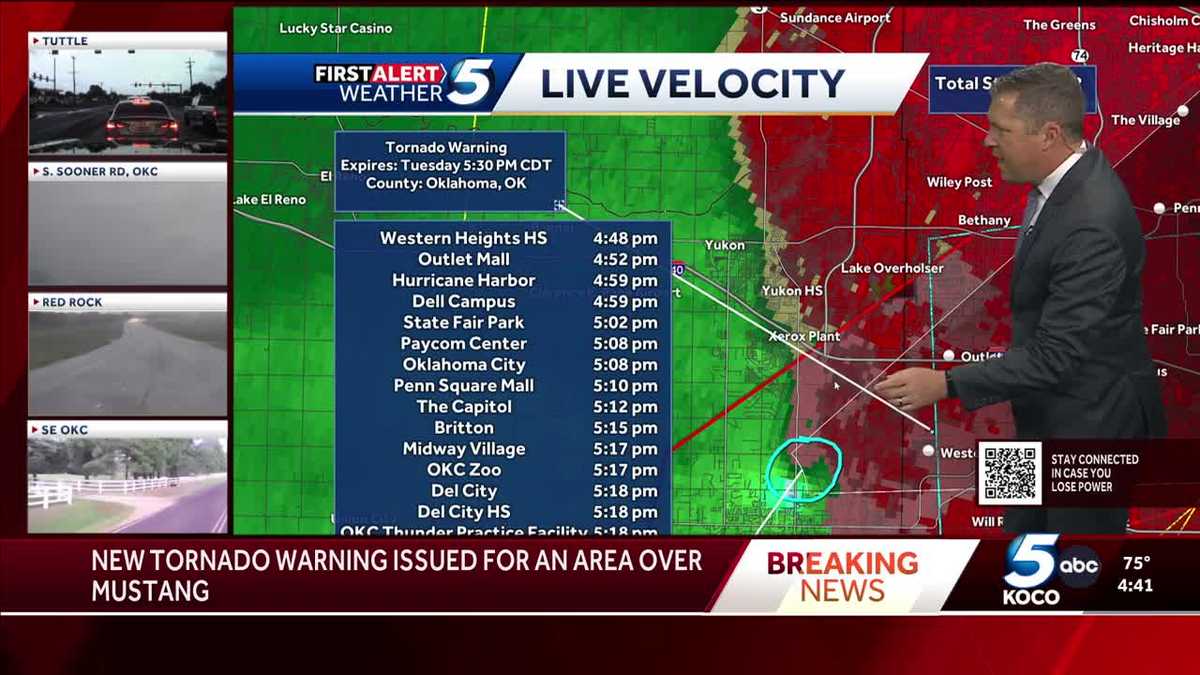
4:36 p.m. Tuesday Update: The tornado warning for Cleveland and Oklahoma County continues through 5 p.m. A severe thunderstorm warning also was issued for Cleveland, Grady, McClain and Oklahoma counties until 5:15 p.m. Damon says you should be prepared to see quick spin-ups with these storms.
4:33 p.m. Tuesday Update: Damon says there could be quick spin-ups with the severe storms moving through the Oklahoma City metro. Any spin-ups or rotation we’ve seen has not touched the ground.
Storm Chaser Nick Smith spotted rotation that he called “really impressive visually” near Interstate 240 and Anderson Road. Open the video player below to watch.
4:25 p.m. Tuesday Update: A tornado warning has been issued for southeastern Oklahoma County and northeastern Cleveland County until 5 p.m. Chief Meteorologist Damon Lane says we’re watching a tornado couplet near Lake Stanley Draper.
Storm Chaser Nick Smith says he could hear the tornado sirens going off near Tinker Air Force Base.
4:15 p.m. Tuesday Update: The tornado warning that was issued for Noble County has been extended until 5 p.m.
4:07 p.m. Tuesday Update: A new severe thunderstorm warning with ping pong ball-sized hail has been issued for Oklahoma County. A different severe thunderstorm warning was issued for Noble and Payne counties until 4:45 p.m.
3:56 p.m. Tuesday Update: Chief Meteorologist Damon Lane says storms moving through Moore has been warned for golf ball-sized hail.
3:52 p.m. Tuesday Update: A tornado warning has been issued for Noble County until 4:15 p.m.
3:48 p.m. Tuesday Update: A severe thunderstorm warning has been issued for Oklahoma County. Other severe thunderstorm warnings were issued for Jackson, Tillman, Garfield, Grant, Kay and Noble counties.
3:45 p.m. Tuesday Update: Chief Meteorologist Damon Lane says storms moving through Newcastle are warned for quarter-sized hail.
3:30 p.m. Tuesday Update: A tornado warning has been issued for far northern Oklahoma near Renfrow and Caldwell. The warning was issued for Grant and Kay counties until 4:15 p.m.
3:20 p.m. Tuesday Update: Another severe thunderstorm warning has been issued for northern Oklahoma County near Edmond for a storm near Oak Tree National and Mitch Park. Chief Meteorologist Damon Lane says the storm is warned for quarter-sized hail.
3:17 p.m. Tuesday Update: A severe thunderstorm warning has been issued for Canadian, Cleveland, Grady, McClain and Oklahoma counties until 4 p.m. Chief Meteorologist Damon Lane says those storms are warned for 60 mph winds.
3:15 p.m. Tuesday Update: A severe thunderstorm warning has been issued for Jackson County until 3:45 p.m.
2:58 p.m. Tuesday Update: Chief Meteorologist Damon Lane says storms that have produced 70 mph wind in western Oklahoma are moving through Dill City, Sentinel, Hobart, Altus and Weatherford. Those storms are tracking east and will eventually move into the OKC metro by the evening commute.
2:55 p.m. Tuesday Update: Non-severe storms are heading into the Oklahoma City metro, but they have the potential to produce strong winds. Chief Meteorologist Damon Lane and Field Meteorologist Michael Armstrong say the storms have had pockets of strong winds.
Damon added that these storms could produce a heavy amount of rain, which pose a flooding threat.
2:27 p.m. Tuesday Update: The severe thunderstorm watch was expanded to include Craig, Creek, Mayes, Nowata, Okfuskee, Okmulgee, Osage, Ottawa, Pawnee, Rogers, Tulsa, Wagoner, and Washington counties.
2:20 p.m. Tuesday Update: Severe thunderstorm warnings were issued for Greer and Kiowa counties as well as Washita County until 3 p.m.
A severe thunderstorm watch also was issued for the following counties until 9 p.m.:
Alfalfa, Beckham, Blaine, Caddo, Canadian, Carter, Cleveland, Comanche, Cotton, Custer, Dewey, Garfield, Garvin, Grady, Grant, Greer, Harmon, Hughes, Jackson, Jefferson, Kay, Kingfisher, Kiowa, Lincoln, Logan, McClain, Major, Murray, Noble, Oklahoma, Payne, Pontotoc, Pottawatomie, Seminole, Stephens, Tillman, Washita, and Woods.
1:45 p.m. Tuesday Update: Storms are starting to pop up near Elk City, Lawton and Chickasha. No severe thunderstorm warnings have been issued with these storms yet.
KOCO 5 First Alert storm chasers are tracking the severe weather. Click here to join the First Alert Ride-Along.
12:40 p.m. Tuesday Update: KOCO 5 Meteorologist Sabrina says we’ll be looking for any storms to develop between now and 2 p.m. The best chance for severe weather and heavy rain is 3-7 p.m.
The risk levels and zones have remained the same, and storms could produce 70 mph winds and ping pong ball-sized hail. The tornado index very low at 2 out of 10.
>> Open the video player below for more from Sabrina.
8:45 a.m. Tuesday Update: The National Weather Service in Norman issued a reminder that there will be a NOAA Weather Radio Outage from June 3-5 because they are conducting a required scheduled software update during that time.
Transmitters in Ardmore, Atoka, Chickasha, Clinton, Enid, Lawton, Altus, Oklahoma City, Ponca City, Wichita Falls, Wewoka, Stillwater and Woodward will be impacted.
This content is imported from Facebook.
You may be able to find the same content in another format, or you may be able to find more information, at their web site.
8:10 a.m. Tuesday Update: KOCO 5 Chief Meteorologist Damon Lane says storms will form west of Interstate 35 by 1 p.m. and track east. The storms will move into southeast Oklahoma by 8 p.m.
The storms could produce golf ball-sized hail and 70 mph winds, and there is still a low tornado risk. A flood watch also remains in effect for much of central and eastern Oklahoma with 2-4 inches of rain.
This content is imported from Facebook.
You may be able to find the same content in another format, or you may be able to find more information, at their web site.
7:15 a.m. Tuesday Update: KOCO 5 Meteorologist Jonathan Conder says a level 2 slight risk has been issued for the majority of Oklahoma, including the OKC metro. The risk zone stretches from west-central Oklahoma to eastern Oklahoma.
A level 1 marginal risk also was issued for far western Oklahoma near Woodward and Alva as well as in southeastern Oklahoma.

The tornado index for these storms is 2 out of 10 in the slight risk zone and a 1 in the marginal risk zones. While the tornado risk is low, Jonathan says there might be some rotating segments and supercells when storms first develop.

Storms also could produce ping pong ball-sized hail and damaging 60-70 mph winds. Jonathan says there may be a rogue gust up to 80 mph.
The biggest risk, according to Jonathan, will be flooding. A flood watch has been issued for most of Oklahoma – excluding western and southeastern Oklahoma – until 7 a.m. Wednesday.

Radar predictor shows storms throughout Oklahoma around 1 p.m. Tuesday. Jonathan says there will likely be multiple waves of showers and thunderstorms, with the first coming through the state around 1-3 p.m.
Video Below: Oklahoma County braces for flash flooding amid heavy rain forecast. Click here to learn more.
Another wave kicks in behind that, and it will likely be raining during the evening commute. Those storms will be south and east of Interstate 44 before moving into southeastern Oklahoma and out of the state by 10 p.m. Tuesday.
Jonathan says there’s also a risk of severe weather coming up Thursday night through Friday morning.
This content is imported from Facebook.
You may be able to find the same content in another format, or you may be able to find more information, at their web site.
Be sure to download the KOCO 5 App to receive customized weather alerts. You can watch our team coverage on the app, too.
>> Check Live, Interactive Radar
>> Download the KOCO 5 App on iPhone
>> Download the KOCO 5 App on Android
>> Stream KOCO 5 weather updates anytime on the Very Local app